Watershed Planning Support
Virtual Public Meeting to Review the Proposed Non-Point Source Implementation Strategy for the Hebble Creek-Mad River watershed in Greene and Montgomery Counties.
View the DRAFT of the plan to review.
The meeting will take place via Zoom, a video conferencing platform, and will be held as follows:
Thursday, May 11, 2023, from 5:00 p.m. to 6:00 p.m.
Access the meetings via computer, tablet or mobile device using this link:
https://us02web.zoom.us/j/89881467126
Enter Meeting ID: 898 8146 7126
Or call in to join the meeting by telephone:
(301) 715-8592 - Meeting ID: 898 8146 7126# US (Washington DC)
(312) 626-6799 - Meeting ID: 898 8146 7126# US (Chicago)
Participation via computer, tablet or mobile device using the link above is encouraged to take advantage of Zoom on-screen meeting features even if relying on the telephone for audio functions. If you are unable to attend, information will also be available for public review on MVRPC’s website at mvrpc.org/watershed-planning-support and at the MVRPC offices, 10 North Ludlow St., Suite 700, Dayton, OH, 45402, during regular business hours (8:00 a.m. – 5:00 p.m., Monday through Friday) and at the Engineering Division at the City of Fairborn, 44 W. Hebble Avenue, Fairborn, Ohio 45324 during regular business hours (8:00 a.m. – 5:00 p.m., Monday through Friday). Written comments regarding the plan will be accepted at the above address or via email at mlindsay@mvrpc.org or by completing a digital comment form until May 22, 2023.
The Miami Valley Regional Planning Commission will support local watershed planning efforts in any sub-watershed in Darke, Greene, Miami, Montgomery and Preble Counties. The Ohio EPA emphasizes the importance of local watershed planning, and development of Nonpoint Source Implementation Strategies (also known as 9-Element NPS-IS, or NPS-IS) for achieving water quality criteria, and/or meeting goals established in Total Maximum Daily Load (TMDL) plans. The NPS-IS ensures that potentially funded projects are: rooted in the best science available; located in areas that will address the worst problems; and that have the administrative, evaluation, and educational components needed to ensure that the water resource will achieve as much long term benefit as possible. Inclusion of water quality improvement projects in an approved NPS-IS is required for the project to be eligible for Section 319 funding.
Locally-based watershed planning allows for the greatest participation of community stakeholders and property owners in the decision-making needed to develop an effective plan to protect resources and/or improve water quality in local streams and rivers. Local engagement and buy-in is critical to effective implementation of any water quality plan.
MVRPC can offer assistance to local watershed planning efforts in a variety of forms.
Mapping and Data Support for 9 Element NPS-IS
Ohio EPA encourages the development of NPS-IS plans at the HUC-12 level – the smallest division of watersheds in Ohio. HUC stands for Hydrologic Unit Code, and is a simple numeric system for delineating discrete drainage areas along streams and rivers. In the Miami Valley, HUC-12s range in size from 8,000 acres to 40,000 acres (average size: 18,000 acres).
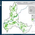
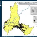
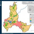
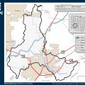
An approved NPS-IS will present and describe baseline conditions in the watershed with maps and data analysis. MVRPC can assist with the development of HUC-12 maps covering data such as:
- Political boundaries, major roadways and water features
- Land Cover
- Impervious Land Cover
- Tree Canopy
Examples of such maps are pictured here. Click on the images for larger view.
Public Engagement and Public Meetings
MVRPC can assist in local watershed planning efforts to engage with residents, businesses and property owners in the watershed. Communicating the goals and findings of the planning process is a necessary and required element of watershed planning. The agency can assist with a whole range of public engagement approaches, ranging from public information outreach, to informational meetings to formal public notice and comment periods.
Stakeholder Convening and Facilitation
Maintaining communications with a NPS-IS process steering committee and other key stakeholders in the watershed is critical to keeping the plan development process moving forward and meeting project timelines. MVRPC can assist with communications and meeting facilitation to keep your project partners informed, engaged and participating in the planning process.
Nonpoint Source Strategies Modeling
In coordination with The Nature Conservancy and the Ohio Kentucky Indiana Council of Governments (OKI), MVRPC has compiled GIS data layers for all HUC-12 watersheds in Darke, Greene, Miami, Montgomery and Preble Counties needed to perform modeling runs of the Agricultural Conservation Planning Framework (ACPF). The ACPF was developed by the U.S. Department of Agriculture to identify potential locations for water quality protection practices on agricultural lands. These geodatabases are available for any Soil and Water Conservation District or other interested conservation organization to use in modeling runs of the ACPF. The Knowledge Exchange at the Ohio State University College of Food, Agricultural, and Environmental Sciences (CFAES) has created an online portal for viewing and downloading ACPF geodatabases for the state of Ohio. Compiled data for HUC-12 watersheds in the Miami Valley are available from the Knowledge Exchange.
Please contact Matt Lindsay at MVRPC for more information on available HUC-12s and how to access the compiled geodatabases.


